Learn how weather forecasters so accurately predicted this storm, even in an ‘El Niño’ climate phase. See how this storm mostly shut down everything in outer East Portland …

Along SE 122nd Avenue, in the Powellhurst-Gilbert neighborhood, three PDOT plows work to clear ice and snow from the highway, as the winter storm blows into outer East Portland.
Story and photos by David F. Ashton
The first unusual feature of this event was that this cold, intense storm lasted over a week. For another, forecasters were hard-put to remember another weather incident in which such low temperatures were accompanied by such intense, gusty east winds – the dangerous combination that brought down trees and limbs all over the area. At its peak 160,000 people in Portland were without power.
And then, although forecasters originally expected a speedy return to warm southerly winds – which did happen for Salem and Woodburn – the jet of cold air through the Columbia Gorge relentlessly kept the ice on the ground and the trees falling over power lines and onto cars and houses for days longer, especially here in outer East Portland.
Some winter storms “sneak up” on us, catching forecasters by surprise. But this time, the frigid gusty weather, bringing freezing precipitation, was strongly hinted at a full week in advance of its arrival on late on January 12.
But, after brief snow, most of the storm’s precipitation followed in the form of sleet – small ice pellets, driven by high winds – and eventually freezing rain. Schools were closed all week, and drivers were constantly counseled by the Portland Bureau of Transportation to stay home and off the roads.
Nevertheless, some families braved the elements to go sledding down inclines at local parks or on slick streets.
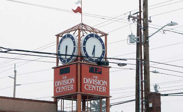
How cold? Although the clock on The Division Center tower is frozen, the sensor measures the temperature at 11°.
Becoming coated with ice, combined with 45+ mph frigid wind gusts, downed historic and stately trees, causing them to smash into houses and vehicles, while also taking out power and communication lines as they fell.
Predicted a week in advance
About those early forecasts, on Thursday afternoon, January 18, National Weather Service Portland Meteorologist Colby Newman told East Portland News, “Our meteorologists were noting that there was a probability of this storm coming into the Portland area six or seven days in advance. The cold temperatures moving down from the north were the first sign of this weather event was coming.”

Inside the National Weather Service Portland office in the Parkrose neighborhood, meteorologists continued to keep an eye on the storm.
“For meteorologists to be predicting 31° and lower temperatures seven days in advance is pretty exceptional, considering that – in many winters – we don’t see much sub-freezing weather at all,” Neuman continued. “It’s especially during this year’s ‘El Niño’ – the ‘warm phase’ of the Southern Oscillation climate weather pattern.”
In fact, during this particular storm, Portland saw the coldest temperatures experienced in the past decade.
“Wintery Mix” conditions in the Portland area occur when warm, moist air – usually moving up from the south – collides with cold, dense air that sweeps down from the north and then is funneled westward through the Columbia Gorge by the air pressure differential, Neuman explained.

Almost any slope, even if covered with sleet, allows a few minutes of sledding in numbing-cold weather.
Why sleet and freezing rain?
For it to snow, the column of air over an area – from high in the clouds, down to the ground – needs to be below freezing temperatures.
However, this storm system moved in from the southwest, bringing a plume of warmer air. So, in the top of the storm clouds, where snow flakes form, they fell through the band of warmer air which began to melt them, and then they refroze in the bottom cold layer before reaching the ground as sleet pellets.
Later in the week, the “warm layer” became thicker, melting the snow but leaving droplets super-cooled, so the precipitation froze the moment it hit the below-freezing ground and other surfaces.

Portland Fire & Rescue crews contend with power lines knocked down by blasting high wind gusts.
The storm that wouldn’t stop
Neuman admitted that the NWS had expected the wintry mix of sleet, snow, and freezing rain to last only until midweek.
“The cold air pool didn’t fully scour out east of the Cascades,” the meteorologist made clear. “Hood River warmed up to 38° – yet, at the same time, The Dalles was in the 20s. The low pressure system over the ocean sucked the cold dense air that was still locked the Columbia Gorge, westward into the Portland basin for days longer.”

Known for growing Portland’s food for more than a century, Rossi Farms in Parkrose is buttoned up for the season.
Instead of the fast melt first expected, it as to be an agonizingly slow warming trend. “There won’t be a rapid melt-off of ice and snow,” acknowledged Neuman.
As for the rest of the winter, Neuman conceded, “We don’t know yet. El Niño’ typically results in above-average winter temperatures in Oregon. But, again, in this storm, we’ve not been this cold for over a decade!”
© 2024 David F. Ashton ~ East Portland News™